Login

Forgot your login?

Cookies have to be accepted!
Your browser's cookie functionality is disabled. Please enable this functionality.

Not a member yet?

Register now
Login

Available for registred users only

Log in to use this feature.

Forgot your login?

Cookies have to be accepted!
Your browser's cookie functionality is disabled. Please enable this functionality.

Not a member yet?

Register now
Filter
Categories
Advanced filters
  • Distance (km)
  • Height
Save filters Reset filter

TrackRank

QRCode

Technical data

Distance10,3 km Height104 m Way down129 m Duration00:00 h:m Date09.03.2013
Scores Author Landscape Fun factor Fitness Technique

Statistics

206 Views Scores 10 Downloads Average
Rate
  • Track data sheet
  • Directions
  • Downloads

Schwierigkeitsgrad leicht bis mittel. Einige kurze Anstiege sind zu bewältigen. Die Loipe befindet sich nur ca. 100m vom beliebten Aussichtsfelsen Penzenstein, der einen herrlichen Blick runter auf das Donautal schenkt, entfernt.


Tour gallery

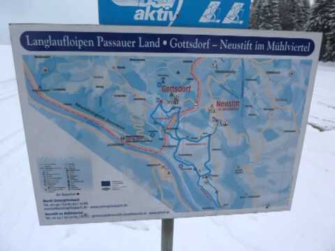
Tour map and elevation profile

  • Open Street Map
  • Google
Minimum height 540 m Maximum height 585 m Detailed view

More about the tour author

rail-com

Comments

PKW bis Neustift Sportplatz

GPS tracks

Trackpoints
  • GPX / Garmin Map Source (gpx) download
  • TCX / Garmin Training Center® (tcx) download
  • CRS / Garmin Training Center® (crs) download
  • Google Earth (kml) download
  • G7ToWin (g7t) download
  • TTQV (trk) download
  • Overlay (ovl) download
  • Fugawi (txt) download
  • Kompass (DAV) Track (tk) download
  • Track data sheet (pdf) download
  • Original file of the author (gpx) download

More about the tour author

rail-com

Share track
Add to my favorites
Remove from my favorites
Edit tags
My score
Rate
Track: Oberösterreich Langlaufguide Mühlviertel - Langlaufgebiet Neustift: Penzensteinloipe kurz
Type: Cross-country skiing
Distance: 10,3 km
Evaluated on:
Duration:
Day(s)
Hour(s)
Minute(s)
Score: Landscape Fun factor Fitness Technique